Blog
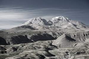
Arica to Putre
August 28 | My GPS Route Data Driving from the seaside port of Arica to the mountain town of Putre requires an elevation gain of 11,500 feet. Tours from Arica to Lauca National Park make the trip up and back in one day, which can be exhausting. I took my time driving up and stopped along the way. About two thirds of the way up the road passes by an abandoned railroad car painted in brilliant colors. A hippy couple lives here and will serve tea with coca leaves while they espouse their philosophy of living off the land. Labels: […]
Read More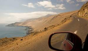
Iquique to Arica
August 27 | My GPS Route Data On the way north to Arica I took a detour to Pisagua, first famous as a landing site for Spanish conquistadores, then a key port for mining industry, then a prison and death camp under Pinochet. A hundred years ago this was a bustling town of several thousand that hosted touring opera companies from Milan and stage actress Sarah Bernhardt. Today, however, only about 150 residents remain and the buildings are largely deserted and decaying. The descent from the Panamericana at 3,500 feet down to the water’s edge is a perilous ride […]
Read MoreLos Prisioneros
My soundtrack while driving hundreds of kilometers along the flat, desolate Panamericana was the one CD I had purchased along the way, a tribute album to Los Prisioneros, arguably the most important band in Chilean rock history. The album contains 18 of their songs performed by a variety of contemporary bands, with styles ranging from ska to hip-hop to heavy metal. I was turned on to this album by the staff at Subterraneo record store in Iquique (Latorre 704). Here’s a classic Prisioneros video from the 1980s for the song We Are Sudamerican Rockers
Read More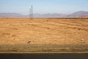
San Pedro to Iquique
300 Miles, Saturday August 25 | My GPS Route Data After leaving San Pedro early, I stopped in Chiquicamata, site of the largest open mine pit on the planet and the last stop for gasoline for over 170 miles. From here a pockmarked road cuts across 40 miles of brown sandy earth to the Panamericana, the main highway connecting north and south. Unexpectedly, this major artery is a narrow two lane road, patchy in spots, and sometimes diverted onto an unpaved dirt road for miles at a time due to construction. The surrounding landscape is completely devoid of any vegetation […]
Read More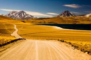
Miscanti and Miniques
The trip to the alpine lakes Miscanti and Miniques was 154 miles round trip at an average speed of 18 miles per hour, as much of the route is on a dirt road climbing from 7,800 feet to 13,800 feet. Miscanti and Miniques | GPS Map | My GPS Route Data from San Pedro View from Toconao Bridge Labels: Chile
Read More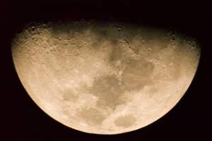
The Moon from the Southern Hemisphere
San Pedro is bustling with tour agencies hawking their services, offering guided trips to salt flats, geysers, flamingo reserves and mountain peaks. One of the more unique offerings is a night time tour of the skies, led by french astronomer Alain Maury and his wife Alejandra. Their home and laboratory in the desert is surrounded by telescopes through which visitors can take a close up look at the moon, planets, and instellar phenomena. Northern Chile is the site of numerous observatories, including the world’s largest, because of the clear sky, minimal interference and high altitude. I took this photo through […]
Read More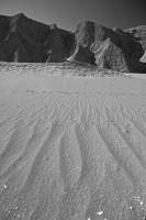
Valle de la Muerte
A few kilometers from the Valle de la Luna is the Valle de la Muerte (Valley of Death). A trail winds its way between steep cliffs and strange rock formations. Halfway through the trail opens to an enormous sand dune, which attracts a handful of sandboarders. Otherwise the trail is usually empty and eerily silent, particularly in the late afternoon when the rocks turn colors and odd shadows appear and then fade away. A good pair of sunglasses is a necessity in this environment, even in winter, due to the clear skies and the sun’s intensity at higher altitudes.Valle de […]
Read More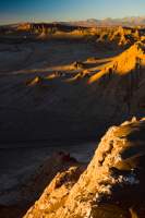
Atacama Desert
The Atacama desert is the driest place on the planet. Hemmed in by the Andes to the east and coastal mountains to the west, some parts of the region have never recorded a single drop of rain. Spanish explorers referred to it as the “despoblado de Atacama,” suggesting it was uninhabitable. Charles Darwin described it simply as “a complete and utter desert” in the Voyage of the Beagle. Traversing the landscape, he reported, “I saw only one other vegetable production, and that was a most minute yellow lichen, growing […]
Read More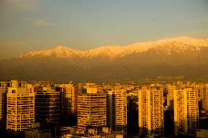
Santiago, Chile
View from the Cerro Santa Lucia | GPS Map After flying in to Santiago airport, I spent a couple of days in the city collecting some in-country travel information (the Turistel road guide was indispensible for driving) and other useful items (a SIM card for my cell phone that gave me a Chilean number). I stayed at the Hotel Foresta in Santiago, which faces the Cerro Santa Lucia, a park built on a steep hill capped with a tower providing magnificent views of the city and surrounding landscape. While there are higher scenic viewpoints around the city, I found this […]
Read More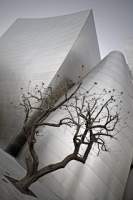
Walt Disney Concert Hall LA 1
The Walt Disney Concert Hall in downtown LA is one of my all time favorite buildings. I’ve been there a few times before, but it’s always fascinating to wander around the outside of the building, especially just before sunset as the metal reflect the changing light and color in the sky.
Read More